The Green Zone: Curling Championship to be tight race for Team Canada
19h ago
Ahead of the Men's World Curling Championship in Moose Jaw, curling legend and analyst Russ Howard joined Jamie and Lock...
A blast of winter weather is coming to Saskatchewan on Thursday.
Environment Canada lead forecaster Brad Vrolijk said a weather disturbance is developing in Alberta, spreading precipitation across Saskatchewan on Thursday, but areas around Regina and Saskatoon are dealing with two different forecasts.
Read More:
“It’s kind of going to be in two main events; the first is a band of heavy snow that will develop through the morning hours and push southeast across the province. Then the second is this band of freezing rain that we’ve seen develop over Southwestern Saskatchewan this morning,” Vrolijk said.
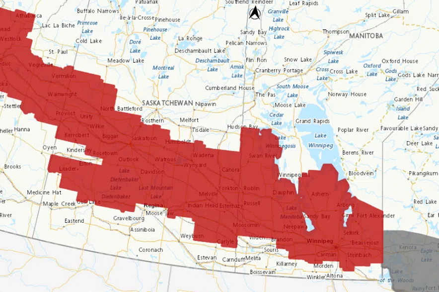
Snowfall warnings stretched across central Saskatchewan on Thursday morning. (Environment Canada)
In Regina, Vrolijk said the freezing rain will be the biggest weather issue on Thursday morning.
A freezing rain warning has been issued to the north, east, and west of Regina, but not in the city itself. It comes as freezing rain mixed with snow is expected to continue through Thursday morning, making highways, roads, walkways, and parking lots slippery.
“It’s kind of on a knife’s edge as to whether it’s going to be freezing rain or snow, but just be prepared for the morning rush hour that you could end up with some ice sticking to your windshield, and the roads might get a little slippery with freezing rain,” Vrolijk explained.
He said the freezing rain is expected to last until noon, before tapering off and switching to snow.
“It’s going to come in quick and be quite heavy, but it should stay north of the Trans Canada corridor,” Vrolijk said.
“Along and east of Highway 11 will be the heaviest snow in the Regina area.”
By the end of the day on Thursday, Vrolijk said there could be up to 10 centimetres of snow north of Regina, but in the Queen City itself, he said there will be significantly less than that.
“If anyone’s traveling north on Highway 11 today, definitely be prepared for poor travel conditions,” Vrolijk noted.
Vrolijk said the heaviest snow is expected to move out of the province by the evening, with a prolonged period of light snow lingering throughout Friday, before tapering off Friday night.
Heavy snow is set to move into Saskatoon on Thursday morning as a snowfall warning stretches across central Saskatchewan.
“This system is bringing a band of quite heavy snow to the region,” Vrolijk explained.
“We’re going to see the axis of heaviest snow stretch pretty much along the Yellowhead Highway corridor from North Battleford through Saskatoon, and then down towards Yorkton.”
Vrolijk said that area can expect 10 to 20 centimetres of snow over a 12-hour period.
“It’s going to be a bit of a mess up there today, with that snow falling a significant amount in a short period,” said Vrolijk.
He said the snow will also be accompanied by fairly strong easterly winds, blowing up to 40 or 50 kilometres per hour.
“In that band of heavy snow, those winds are also going to be whipping it up, and we expect to see very poor visibilities at times and pretty bad travel conditions along the Yellowhead Highway corridor,” Vrolijk added.
The storm will likely leave people in the Saskatoon area with some shoveling to do.
“We are expecting the snow to pile up quite quickly,” the forecaster said.
“Snowfall rates could exceed three to four centimetres per hour at times, so probably near-zero visibilities at times, and just heavy snow and wind.”
Vrolijk said the snow is expected to ease up in the region by Thursday evening.
The latest updates on the snowfall warnings can be found on Environment Canada’s website, and current road conditions can be found on the Saskatchewan Highway Hotline.